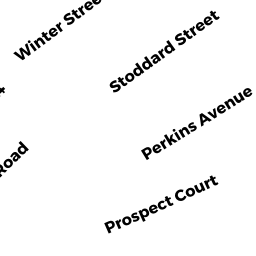
7 PERKINS AVE
Owner Information
TOUSEY JOYCE A
7 PERKINS AVE
NORTHAMPTON, MA 01060


Property Details
7 PERKINS AVE is classified as a Two-Family Residential (4).
The primary structure on this property was built in 1900. There are 720ft2 of built area within this property. There is 2,121ft2 of residential/living space within this property. This property is listed as having 8 rooms. There are 2 units within this property.
7 PERKINS AVE is valued at $405,900. The land is valued at $165,100 and the structures are valued at $240,800. There is an additional valuation of $580 on this property.
7 PERKINS AVE was last sold on Friday, April 1, 1994 for $91,600.
Assessment data from fiscal year 2020.
Flood Data
According to the FEMA National Flood Hazard Layer, this property does not appear to be in a flood zone. It may also be in an area not yet reviewed. Nonetheless, confirm this information prior to taking any action.
To view the flood hazards around this property, create a FEMA "Firmette" Map of the area around 7 PERKINS AVE.
Broadband Internet Providers
| Provider | Type | Bandwidth (mbps) | |
|---|---|---|---|
| Verizon New England Inc. | DSL | 15 | 1 |
| GCI Communication Corp. | Satellite | 0 | 0 |
| Comcast | Cable | 1000 | 35 |
| HughesNet | Satellite | 25 | 3 |
| Viasat Inc | Satellite | 100 | 3 |
| VSAT Systems, LLC. | Satellite | 2 | 1 |
Broadband service provider data from December 2020.
Adjacent Properties
- 169 PROSPECT ST
Three-Family Residential owned by MARTIN ALEC & MARY BOWEN - 163 PROSPECT ST
Apartments with Four to Eight Units owned by ROBERTSON CHARLES R & DIANE S - None
Undevelopable Residential Land owned by BREWER SARA A & DIANA J BREWER - 4 PROSPECT CT
Single Family Residential owned by GREENLAW ROBERT A & SHEILA M - None
Undevelopable Residential Land owned by UNKNOWN